Friday, April 10, 2015

PCT 2014, Day 45: Mount Whitney


DAY 45
June 8th, 2014
To Mt. Whitney and back 

When Zach’s watch beeped at 6:30 that morning, I knew I was ready to take on the 14,505-foot-tall Mt. Whitney. We ate our granola in bed, then packed Zach’s backpack with some warm clothes, some water and a filter, some snacks, and our emergency supplies. We left our tent set up with my backpack inside. For our 14-mile excursion to Mount Whitney, we only needed a daypack.

I took the first turn on the pack, and we left our campsite behind and followed the edge of the stream toward the ridge of mountains before us. It was a perfect day for a hike: an early morning sun and cloudless sky washed us in light.

Before long, we were skirting the edge of a wide meadow cut through with meandering streams. This particular feature of Sierra landscape never ceased to make me feel happy: I loved watching the squiggled lines flowing through the lush turf, gathering into pools, trickling into new streams.

We paused at the edge of a lake, named Guitar Lake because of its shape, and gathered water from an outlet. We saw some friends there: The Prospector and Chop Chop, as well as The Animal. In high spirits, we all chatted. Marmots peeked out at us as we walked by, sometimes letting out squeaks to alert the others that possible gullible tourists were here to give them food. 

(We later heard a story from a woman who said that she actually poked a curious marmot with her trekking pole. The marmot just sniffed the tip of her pole, as if flaunting the fact that she couldn’t hurt it.)

From Guitar Lake, we emerged into a more alpine area, and had a clear view of where we were headed (although we still weren’t sure exactly which peak in the ridge was Mount Whitney). Someone had told us that west side of Whitney just looked like “a big pile of rocks.” Looking at the backside of this monumental mountain, I could see that the person was right— in the same way that the Grand Canyon is just “a big hole in the ground.” 


The entire landscape around us was a pile of rocks— splintered shards of granite  the size of cars down to the size of pebbles that lay heaped at the feet of a raw, ragged ridge of vertical rock, chipped away by the ages, heaped in rubble. The scale of this mountain was mind-blowing. 

Looking up the side of Whitney
We passed into its shadow, heading for a steep set of switchbacks. I began to feel exhausted and a little faint (“Elevation!” I announced), so Zach took the daypack and led the way. The path was a bit steep for a while, and then settled into a predictable pattern of switchbacks. This side of the mountain (though apparently not nearly as steep as the east side) was pretty sheer, and I found myself hugging the inner wall of the trail as we hiked.

Zach and I are both afraid of heights. Fortunately, my fear of heights only extends as far as my brain can comprehend the distance it will fall. What this means in practical terms is that I was jittery all the way up the switchbacks, but once we neared the top of the ridge, my brain couldn’t process the height we were at, so it just gave up being scared. Zach was not so lucky.
I swear it looked steeper in real life…

The part that scared me the most on the whole hike was when we had to cross a sheet of snow that cut a diagonal across the path. It had footprints on it, but if I slipped, I saw that I’d be sliding down a very steep bank of snow about five hundred feet down. I fretted as Zach crossed it, then followed, stepping carefully into the icy footprints and leaning toward the inner side as much as possible. I couldn’t imagine crossing it in the dark, as some people did!

On the way up, we met some of the early birds coming down. Sad Fish said that the sunrise was incredible, but we still didn’t envy him for waking up so early. We met Matt and Sam, and stopped to chat. They said that the trail ahead had some tricky spots, but nothing too hard. We talked about plans for after the Sierra. We learned that we were both hoping to meet up with family at Echo Lake, near Lake Tahoe. Matt, chuckling because of our never-ending game of tag, said, “Okay, we’ll see you in Echo Lake!”
Guitar Lake

After that day, we never saw them again. They blazed ahead of us, and though we once almost caught up with Sam in Oregon (less than a day behind, according to the trail registers), we never quite caught them. But every time I saw their names in the trail register, I thought of them, and I remembered fondly our first conversation, at the water spigot in the first sandy mile of of the PCT. They will always hold a special place in my heart.


As we continued up the side of the mountain, we paced The Animal for a while, but once again, only because he kept on dashing off on side trips— trying to climb a mountain peak here, scrambling up a scree field there. He stood on the edge of a precipice and let out a loud whoop. Zach and I, who both get dizzy and feeling of vertigo when seeing someone near a ledge, asked him to get down, for the love of everything. 

At last, we joined up with the trail that came up from the other side of the mountain, called Whitney Portal. We sat on a rock shelf near the junction and split a Clif bar. From this side we had a gorgeous, dizzying view of the snow-streaked mountains to the west, interspersed with deep blue lakes that were still covered in frost-patterned sheets of ice. The sky was still sunny and blue, and the breeze mild. We didn’t need any of the layers we had packed. It really couldn’t have been a more beautiful day.

Now we joined with the trail that led 1.9 miles along a jagged, boulder-strewn ridge, with dramatic drop-offs on either side, to the highest point of Whitney. It wasn’t as narrow as Angels Landing in Zion National Park that I had hiked a few years ago, but there were certainly going to be some tight spots.

By this time, my fear of heights had pretty much gone away except for the occasional butterfly in the stomach, but it was all Zach could do to hold it to together as we started along the ridge. At last we reached a narrow space, where the trail turned a corner, swooped in a wide half-circle and disappeared out of sight. The half-circle was the rim of a drop that looked, from our angle, nearly sheer, and the trail appeared to be only about a food wide. It was crumbling in some places.

I glanced down at the fathomless drop in front of us, then took a deep breath, psyching myself up to go on. However, Zach turned away and crumpled onto a flat stone, his breath coming in short gasps. I sat next to him and tried to help him calm down. I knew that if he had been alone, it wouldn’t have been so tough— him worrying for my safety made his fear of heights worse.

For almost half an hour, we sat there. Zach hyperventilated a little bit, and I tried to be patient, and kept reassuring him that we did not have to go on. I wanted to reach the summit of Whitney, I really did, but if he wasn’t okay with it, we could turn back right now. After all, he’d be having to face this fear twice: once on the way there and once back.

Neither of us wanted to turn around, though. So we sat, and I felt somehow comforted that Zach had finally had a minor breakdown. It was his turn, after all!

What tipped the scales was talking to a woman and her husband who were hiking back from the summit. They told us that, aside from one tricky spot covered in snow, this was the worst the trail ever got, and they described the terrain to us before wishing us luck and continuing down. Armed with a bit more knowledge, Zach stood up. Then, with shaking steps, he began walking along the narrow trail, one hand skimming the rock wall to his right, eyes resolutely forward. I followed him, and, as soon became my habit in the High Sierra, I hummed a song as I followed him. As long as I was humming, he knew I was safe.

The trail turned out to be less scary than it appeared from our initial angle: the path was a couple feet wide, and the cliff was not as sheer as it could have been (although I still wouldn’t have wanted to take a tumble down it!). The washed-out area was a bit scary, but we skirted its edge and got past.

The trail now cut its way between gigantic columns of rock, with dramatic (and this time entirely sheer) cliffs that opened up first on one side, then the other, but mostly to the right. Zach couldn’t look at these openings, and I only allowed myself glimpses— glimpses that told me we were very, very high up.


After a while we came to the next obstacle. The trail was skirting a cliff off to the left at the time, which was interrupted by a column of rock. A patch of snow had sunk into the narrow pass between the column and the cliff, turning that small section of trail into a six-foot-tall ice slide on either side. The right side was a solid wall of rock, but the left side was just a column jutting up between two very steep cliffs.

Someone had hacked footholds into the near side of the snow, but it still looked like a slip could send you careening off the cliff. Zach faced the stone wall on our right and tried to breathe calmly. Using both hands and feet, I scrambled up the ice to the top to check it out. The other side was a definite ice slide, which would shoot you out onto the three-foot-wide trail next to the sheer cliff.

“It looks fine,” I said to Zach. “I’m going to try it, and then you can follow.”

This was actually a bad idea. Zach watched anxiously as I slowly lowered myself down, trying to do a controlled slide on my feet while crouching. This failed, and my feet flew out in front of me, plunking me on my butt, and I slipped down the side and hit the bottom. Zach said it looked like I was going to be launched off the side of the cliff, and he nearly had a heart attack.

To me, the motion was sudden, but not unexpected, and I landed solidly on the trail. Feeling happy to be over the obstacle, I told Zach to follow. He slid down as well, then stood next to me, breathing deliberately.

“Just a little further,” I told him. 

“I thought you were going to die,” he said flatly. 

“I’m sorry. But the couple said it gets better after this!”

Sure enough, within a few minutes the cliffs became less severe, and soon the trail spilled onto a sloping scree field that made up the summit of Mount Whitney. Huge jagged edges of bedrock stuck out to our right, covered in scree up to their tips, as if an immeasurably huge mountain had been wrenched away from its roots, leaving rubble on every surface behind it. The trail wound along these jagged pieces, over a small snow field, and then over a gently-sloping tumble of boulders. Our spirits rose as we glimpsed stone-cabin emergency shelter ahead of us. We were almost there!

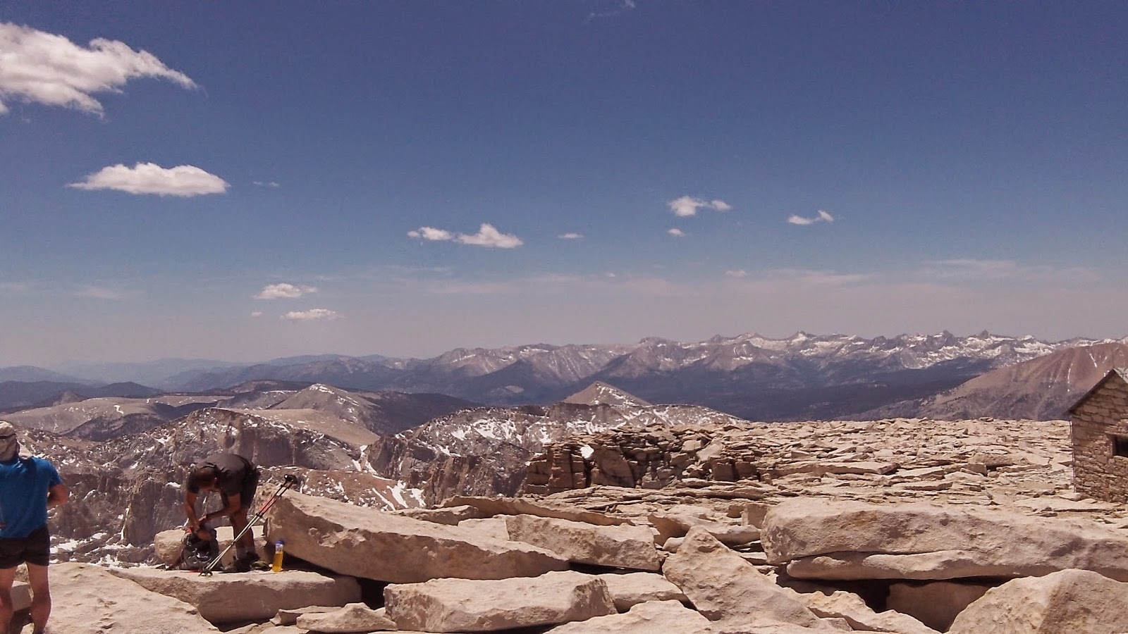
At last, hearts racing (not just from the exertion), Zach and I stood on top of the highest mountain in the US outside of Alaska. We were greeting with clapping by The Animal, Prospector and Chop Chop, as well as a few day-hikers. A metal spike was driven into one of the boulders, marking the exact highest point, and Zach and I stood on it while The Animal took our photo. Our fear on the way up made the victory that much more satisfying!


A tapestry of snow-speckled mountains spread out as far as we could see to the north, west, and south, but to the east we saw the lower, sandy mountains of the desert.  The 360 view was too much for our minds to process.

“Right now, we’re higher than the Rockies,” Zach said. “All of them.”


Zach wouldn’t let me go anywhere near anything that remotely resembled a ledge, and he sat in the middle of a large boulder. We ate some peanut butter wraps with trail mix in them, and watched tiny chipmunks scurry about. (“What on earth do they eat up here?” Zach wondered.)

We chatted with some people from the area, who offered to share their “Mountain High” beer with us, which we accepted. They had hiked up through Whitney Portal, a 22-mile round-trip that involved a lot of intense climbing and scary cliffs. Zach and I were very glad we’d been able to come up from the west side.

We tried to get cell phone reception, since we hadn’t had any in a week, but had no luck. Two PCT hikers, a couple we hadn’t met before, asked if we wanted to borrow their phone. Their names were Kit and Rimshot— Kit had a friendly smile and a welcoming aura about her, and Rimshot looked like most of the thin, bearded men on the trail at the time, although the impressive length of his beard suggested he had been working on it for a while. Thankful for their offer, we made to call Zach’s grandparents, who were hoping to meet us at Echo Lake in a couple weeks. We let them know that we were on track, and asked them to spread the word among our families that we were still alive.

We stayed there for an hour or two, taking in the scenery as clouds rolled in and hikers came and went. At last, we said farewell to the view, signed the trail register at the cabin, and headed down. Now fluffy clouds were lowering over us, swept along by the increasing wind, although it was still nice and warm.

We wound our way through the scree field, across the slope of tumbled boulders, and back to the narrow cliff-edged trail. The snow slide proved to be more of a challenge going up— we saw some people climb along the rocks right on the edge of the cliff, but we knew there was no way we’d do that. We managed to find footholds in the icy slide, and scrambled over without incident. We retraced our steps along the narrow trail, over the washed-out section, and back into safe territory for the huge set of switchbacks down.

To give a sense of scale, see the person in the red shirt hiking along the trail?


The trip down the mountain certainly seemed a lot shorter than the hike up! It seemed like almost no time had passed before we were passing Guitar Lake. Behind us, a cover of ominous-looking gray clouds shrouded Whitney’s peak. We had left at just the right time.

The Animal hiked and chatted with us for a while, which was fun. We also got to see the couple who had helped us gather the courage to make it to the top, and they were happy that we had made it.

Soon we left the cold gray stone and marmots behind in favor of green fields and forests. By the time we reached our camp, it was threatening rain, and we decided that we might as well camp here again. Zach worked on cooking dinner while I went to get water.

Kit, who was also camped in the area, was gathering water there as well. We began chatting, and I soon learned that she and her husband were Christians! They were the first Christian hikers we had met on trail, and it was like meeting a long-lost family member. I realized how desperately I missed my Christian friends and church community.

After supper and sock-washing, Zach and I went to bed, exhausted but satisfied.


~~~

Thursday, April 9, 2015

PCT 2014, Day 44: Gaining Elevation


Day 44
June 7th, 2014, Saturday
754.5 to one mile past 766 on a detour

We knew we only had to walk about 13 miles to reach our “base camp” for our Mount Whitney hike, so we slept in and made no effort to start early. It was such a luxury to sleep in without worrying about the sun getting too hot— in the Sierra, the midday sun felt good.

Still, when we did start hiking, I felt like all my energy was being sapped away with each step. I first blamed it on the elevation, but in subsequent days, I realized that the elevation had little to do with how I felt. This was when I first began to feel the effects of malnourishment.

We slogged up boulder-strewn mountainsides, winding our way through fragile alpine areas (and seeing lots of marmots!) and back into forest. At last, we tackled the last big climb of the day: a set of switchbacks that gained 900 feet of elevation in one mile. As we struggled up, I experienced something that would become too familiar in upcoming days: feeling like I was going to hyperventilate. I started feeling dizzy, and as I tried to draw breath, I felt my heart racing and my breaths growing short. I practically collapsed on the ground, trying to breathe and calm down. Zach insisted I eat one of our carefully-rationed Snickers.

While we sat there, we were passed by a few people who had hiked in just to climb Mount Whitney. They were all enthusiastic, and confidently blamed my condition on the elevation.

At last, I felt stable enough to continue on, so we finished the switchbacks and followed the PCT to mile 766. Here a side trail split off to Lower and Upper Crabtree Meadows, both popular base camps about seven miles from the peak of Mount Whitney. As we departed the PCT, chipmunks scurried out of our way on the trees.

As we passed Lower Crabtree Meadows, we saw a bunch of people we knew, including Matt and Sam. They were all setting their alarms for 2:30am and hiking up Whitney in the dark so they could see the sunrise. I admired their dedication!

Both sets of Crabtree Meadows were as gorgeous as you’d expect a high alpine meadow to be: a huge expanse of grass, wound through with threads of a clear stream. A herd of deer grazed in the distance, and huge mountains rose up on every side. We looked around at the encircling peaks, but couldn’t for the life of us tell which was was Whitney. Since Whitney is surrounded by a few other 14-ers, it’s hard to spot. Tomorrow we’d follow a trail and find out which peak was the one to summit.

We soon found the official campsites: there was a stony stream, a wide meadow, and a grove of pine trees with about a dozen tents pitched on the pine needles. There was also a heavy-duty bear box, a large metal container with a mechanism to open it. A note taped on the top, from the Forest Service, said, “Sierra Trail Magic: Leftover food inside!” We practically tore the box open and found some canned goods. They had been picked over, but Zach pulled out a can of black olives.

“Do we have a can opener?” I asked.

Zach stared at the can with frightening intensity. “I’ll find a way to open it.”

I was a bit worried that he’d tear into it with his teeth.

We secured a place to camp for the night, a bit away from everyone else. Zach successfully borrowed a can opener from a group of hikers, then proceeded to eat the entire can of olives on the spot (I don’t like olives, incidentally). He made some soup for us to share, and I gathered and filtered water— the cleanest, purest, most amazing water I had yet tasted.

We saw a sign at the campground that said “TOILET” with an arrow. Never ones to pass up convenience, we went in search of it. When we found it, we started laughing. It was a single throne, complete with a seat and lid— sitting in the open air, facing the campground. It had a wall behind it, sheltering it from nothing in particular. You could sit on the throne and conveniently wave to the people setting up camp thirty yards away!

That night, we went to bed early, going over our plan for the next day. Tomorrow, we were going to climb the highest mountain in the contiguous US, and I was excited.

~~~

Wednesday, April 8, 2015

PCT 2014, Day 43: The Awe-Inspiring Chicken Spring Lake


DAY 43
June 6th, 2014, Friday
736 to 754.5

We got up late that day, and fussed with the backpacks for a while— Zach’s backpack was starting to dig into his hips (a problem that got worse as he lost more weight). But at last we were back on the trail, following the gentle rise and fall (but mostly rise) of the trail through forests and into steadily more alpine climate.

That day we were struck again by how unbelievably gorgeous the landscape was, all boulder-tumbled and jagged-peaked and twisted-treed and splashed with patches of snow. We saw grayish-white birds with black wings— Clark’s nutcrackers— and heard their raucous cries. There was always something new to admire.


In late afternoon, we paused for water at a spring, then decided to follow the spring to a nearby lake, called Chicken Spring Lake. Its goofy name was an insult to its true nature: it was an impressive body of water, silver-gray, that lay at the base of a massive gray cliff. The granite rose up dramatically on the far side of the lake to a dizzying summit of bare rock tipped with snow. To the right and left of the lake, the jumble of rocks were less sheer, pure white, and interspersed with tough conifers. Zach and I both immediately thought of the lake outside the Mines of Moria in Lord of the Rings. In fact, the majestic ominousness of the lake made me hesitant to go near it for fear of a watcher in the water!


We lay on a boulder for a while, lying side by side, soaking up the patches of sunlight. But night was coming on fast, so we walked back toward the trail.

“Look!” Zach cried, pointing. I looked and saw our first marmot! It quickly ducked behind a boulder, but throughout the day, we saw several of its friends. They look exactly like a bushy-tailed version of a woodchuck. The ones in the Sierra had a reddish shade to their coats, and their tails were bright russet.

From there, we walked through white boulder fields, interspersed with trees, then followed the edge of a ridge, with more ridiculously gorgeous scenery: the sun falling slowly behind jagged blue mountains that swept up from the plain. We passed a sign that announced we were now in the Sequoia and King’s Canyon National Park. After a few miles, we found a campsite near an alpine meadow.

That night, we finished Book 5 of Lord of the Rings and began Book 6, since I kept begging for him to read just a bit longer. It was far past “hiker midnight” (9:00, the time most hikers are asleep) when Zach put the Kindle down.

~~~

Tuesday, April 7, 2015

PCT 2014, Day 42: An Existential Crisis


DAY 42
June 5th, 2014, Thursday
?? to 736

We woke up that day intending to make it very far, but we were slow in getting ready. The landscape had changed: we were walking through wide pine forests and landslides of tumbled boulders interspersed with trees, though we were mostly in the woods. Dramatic columns of sandstone reared up on either side now and then. It was undeniably gorgeous. But here, at the beginning of the new phase of the journey, we had our first huge existential crisis.

It started with a conversation about whether or not Christians should do dangerous things or take dangerous occupations, since it puts them in danger of dying instead of living on to share the gospel. (A very interesting debate, though I tend to have a negative reaction to idolizing safety.) This turned to the question of, “Should a Christian climb Mount Everest?” which turned into a question of, “Should anyone climb Mount Everest?” which led to, “Should anyone do something really hard even if it’s been done before?”

Which of course, led to the question, “Why the HECK are we hiking this trail?”

Certainly not to do someone no one had ever done before. Over a thousand people were hiking the trail this year alone. Not for the nature— we could do a much shorter trip, or skip around and hit up the spots we thought were most beautiful. Not to “find ourselves”— we knew exactly where and who we were, thank you very much.

We also could not pretend that we were doing this for missions. Despite being among pretty much exclusively non-Christians, we didn’t usually talk to people about God because it never came up in a two-minute conversation about how many liters of water to take for this stretch. (“And speaking of water, let me tell you about the Living Water of Jesus Christ!”)

We were away from our families, and would be for several more months.

We were aching, tired, and hungry, and would be for several more months.

We were homeless.

We were not earning money, and would probably end up in debt.

Why the heck were we doing this?!

I don’t know how long our conversation actually lasted, but it felt like it went on for hours as we talked in circles about it. We talked about our 40 days in the desert. We talked about how neither of us felt that we had learned anything particularly meaningful or spiritual on this trip— no more than we did at home. The famous explanation for why do anything, “Because it’s there,” seemed pretty lame in such a circumstance.

In the end, Zach was only able to console me when he compared the trail to art. “If you felt the urge to create art,” he asked, “even if you knew you’d never make money off of it, or never serve any utilitarian purpose with it— would you still make art?”

“Yes, of course.”

“Then we have to hike this trail.”

That answer was enough to keep me going, at least for another day.


(Somewhat failed selfie)
Sometime during this day, we reached 10,000 feet of elevation, a height we’d stay at, above or near for the next few weeks. Fortunately, we never had any adverse reactions to the elevation (although I often tried to blame my breathlessness on it). 

That was also the day when we began to realize that we were in ridiculously picturesque scenery. No matter where we looked, in any direction, we saw a scene from an outdoors calendar. Huge tumbled boulders, pinnacles of rock, massive-trunked cypress trees twisted by wind and weather, open pine forests, tumbled bare peaks with dead trees, sudden views that revealed the jagged pale gray line of snow-capped mountains in the distance, unexpected windows looking back into the desert far below. The gorgeousness, at least to my Midwestern eyes, was exhausting.


It took me ages to figure out why the Sierra felt so different from the desert forests we’d traversed before, and it finally struck me: clouds! They billowed in the sky overhead, constantly morphing, covering and revealing the blue. The desert had some clouds, but nothing like this.

We were alone for most of the day, which was quite a change after the busyness of the desert. We did hike for a while with a man who had grown up in Switzerland but lived the past twenty years in Seattle. 

People spread out a lot more in the Sierra, since camping and water were more plentiful. Also, a lot of people dropped out after the desert, because, as someone said, “There aren’t any party spots in the High Sierra.”

As we were walking along a flat stretch of woods near the end of the day, Zach and I finally got around to calculating our planned side day-trip to Mount Whitney, the tallest mountain in the lower 49. We suddenly realized that we either had to do two backbreaking days, or three short days, to make the schedule line up. After some debate, we decided on the latter. After all, we’d gotten a bunch of extra food in our boxes. We felt pretty confident.

That night, we set up camp on a nice flat patch of pine needles (camping was so plentiful here!). We ate refried beans and Fritos, and I insisted that we sit several yards away from our tent to avoid attracting bears. 

We laid in bed, bundled up against the chilly onset of night, and read Lord of the Rings together, putting the troubling questions of the day aside. We had mountains to climb and a trail to finish. Maybe someday we’d figure out why this was something we had to do.

~~~

Monday, April 6, 2015

PCT 2014, Day 41: Into the Sierra


(Sorry for the delay in posting— it’s been a crazy week. Also, hope you all had a good Easter!)

DAY 41
June 4th, Wednesday
702.2 to ??

The next morning, we knew that we were ready to leave Kennedy Meadows. Unlike some of the other places we’d been to, there was no good way to celebrate here unless you wanted to spend a bunch of money. We got up and packed up, surprised at how chilly it was. We ate some hiker-box oatmeal for breakfast, worked on getting our food together, and headed out.

Our new bear canisters were difficult to get used to. First of all, we couldn’t hope to fit all of our food into them. We had one large and one small one, made of blue plastic with black lids, covered in bright orange tape and little Dutch-themed stickers by previous owners. They didn’t fit very efficiently into our packs. In fact, our entire packing systems had to be revamped to accommodate them. We tried to pack the smelliest foods inside the canisters, and left the unopened jars of peanut butter, the bags of pasta and potato flakes outside in our food sacks. 

Zach and I waved goodbye to the very few hikers on the porch that morning. Most people were still asleep (and would wake up with terrible headaches, I was sure). 

We walked on the asphalt back to the trail. And with a deep breath, we took our first steps into… the Sierra.

It looked exactly like the desert. Zach and I jokingly grumbled about this as we walked over sand between short, scrubby brush. A mile later, we crossed a road, passed a campground, and found ourselves in a grove of charred and blackened trees.

“No!” I cried, throwing a (for once) fake hissy fit. “We’re in the Sierra now! No more burned trees! No more sand! Lots of water everywhere!” Zach agreed with me.

Eventually, we left the burn area and continued in trees— tough conifers growing out of tumbled boulders.

I honestly can’t remember how exactly the landscape changed. I feel like we were heading up a hill, out of trees, and the branches parted like a dramatic scene in a movie. 

Stretching out before us was the one of the most beautiful vistas I had ever seen in my life.

I look back on my photos and it looks like nothing special. It was a stretch of wasteland, like so many wastelands before us, of scrubby grayish-green brush on flat ground. But in person, it was truly awe-inspiring. It grabbed my sense of scale and wrenched it from my grasp, stretching out into a massive, miles-long field, sloping up into fir-covered hills, which multiplied into gray peaks in the distance, and there, on the edge of sight, jagged teeth of snow-covered mountains. A tiny cabin on the edge of this dream emphasized its hugeness. We felt like we were tiny specks on the edge of a massive green bowl. And— really— for the first time— I felt like we had reached the High Sierra.

The euphoria I felt at that moment was painful. I felt swallowed by this landscape.  I felt excited beyond all reason that we had made it through the 700 miles of desert that had been such an unknown factor in my head.

And I thought, Oh my gosh. We’re actually going to make it.

I cannot possibly convey how much more incredible this looked in real life.
Zach and I lingered under a tree in the field and ate a snack, taking in the scenery. Then we continued on the trail, which soon left the open field and wound along the edge of the pine trees before climbing up one of the hills and diving over the other side, leaving the initial field behind. Still, wide flatlands spread out to our left, and we saw the river we’d seen the previous day, the Kern, spread out into a lazy delta that squiggled through the land. After the desert, it seemed ridiculous to see that much water spread out over that much land. We were excited to see that we’d be crossing it in a couple miles, and we hurried on.

After winding through a grove of trees, we found ourselves all at once at a steel bridge, arching gracefully over the wide, shallow stream. The banks spread out on either side of us, speckled with hikers, lying in the shade or the sun with their bare feet spread on the grass.

Grass. 

It was one of those moments when I didn’t realize how much I’d missed something. I stared at the swatch of lush green grass, growing like a well-tended lawn along the banks of this beautiful stream, and I felt tears stinging my eyes. We had been in the desert so long, and we were finally out of it. I dropped my backpack and fell prostrate on the grass, tussling with my shoes to pull them off so I could bury my toes in its soft blades. The other hikers made no comment; I had a feeling each one of them had been through something similar.

After I got over the amazement of the grass, I noticed something that I had ignored at first: the swallows. There were hundreds of them, darting under the bridge, wheeling and zipping through the sky, fluttering over the water, making a constant squeaking chatter. They were a delight to watch.

Zach began working on cutting up summer sausage and boiling pasta for dinner. I grabbed the mass of dirty socks and waded into the stream to wash them. It was the first time I was able to wash our laundry in a flowing stream, where I didn’t feel like I was polluting someone’s water supply. The water, warmed by the sun, glided like silk around my feet. The bottom of the stream was coarse sand, which massaged and exfoliated my callused, dirt-encrusted feet. As I dug my feet deeper into the sand, I felt a growing sense of euphoria, like I was a bubble of light hovering between the warm water and the flitting swallows over my head. 

That was when I learned that the Sierra (while mostly being difficult and back-breaking) was one giant natural drug.

Feeling a bit dizzy from euphoria, I clambered back onto the bank and sat with my feet in the sun. My feet looked unnaturally white to me: it was the first time since I left San Diego they had been clean, since even a thorough scrubbing with soap in the shower couldn’t get to the nitty-gritty dirt. Zach and I ate summer sausage and pasta and enjoyed the beautiful, sun-soaked evening.

We considered staying there for the night, despite it not being very far out, but we decided to nix this idea when a horde of very clean-looking hikers showed up. They had left the southern terminus almost a month before we had, and had traveled only four miles in the past four days. They were splashing in the river, gathering materials to make a bonfire, and pooling their supply of marijuana for the night. Zach and I decided to go on.

We put our shoes back on our clean feet, hung the wet socks from the outside of our backpacks to dry, and hiked over the Swallow Bridge and onto a sagebrush-filled landscape. After a mile or so, we were back in the woods, walking through a wide pine forest that stretched as far as we could see on all sides. We still made camp pretty early, on a slope in a pine forest near a stream.

We set up next to a fallen log, and left the rain fly off because it wasn’t too cold. I dutifully placed our bear canisters twenty paces from our tent, and we stuffed the rest of the food into our tent. 

That night, the stars shone through the pine branches like diamonds.

~~~


Wednesday, April 1, 2015

PCT 2014, Day 40, Continued: Kennedy Meadows

My camera died on June 3rd, so the photos in this entry are actually from the next morning, right before we left.

June 3rd, Tuesday
Mile 702

Zach and I dropped our backpacks with a horde of others in the General Store’s front lawn, a dusty enclosed area with sawn-off logs and dilapidated benches for sitting. The store front looked exactly as I had imagined it: dusty, rustic, with weathered wood. A newer addition was on the side, a huge deck covered in plastic tables, which were, as mentioned, crammed with hikers. Zach and I wandered to this first, seeing a bunch of people we knew. A line of hiker boxes were off to our left, along the main building: above them, on the worn wood siding, were hung many signs, such as: “People say I have a bad attitude. I say screw ‘em!” and “I don’t normally drink beer. But when I do, I prefer to drink a lot of it,” and “FISHING” and “Warning: This Establishment is Frequented by Pickpockets and Loose Women,” with a large “KENNEDY MEADOWS” sign in the middle. 

The store was dark and crammed with convenience food, none of which had any prices on them. They had a tab system where you gave them your credit card, and they gave it back when you left. Zach and I knew this was a bad idea, and decided to buy things as we went.

Everyone there was buying with abandon, without the slightest clue of how much they were spending. Every group we saw already had multiple empty six-packs of beer on the tables next to them. It was 10 in the morning, and a good half of the hikers were already buzzed, with another percentage already considerably wasted. Everyone was in a celebratory mood. I felt vaguely glum and eyed the restaurant menu. Maybe Zach and I could split a burger for lunch.

Zach and I took care of business first. We picked up our boxes ($5 fee for each): one was a food box, and the other was a shoe box, packed with extra Clif bars and Snickers. I pulled out my new pair of shoes: Asics trail runners with heavy tread, much more heavy-duty than the flimsy (now completely shredded) New Balance shoes I wore. I tried on the Asics, and they felt unbearably hot and tight. I hoped they’d feel better once I broke them in. 

I took stock of our food and organized it while Zach went to a nearby trailer home to pick up the bear canisters we’d been able to reserve through a loan program (a $5 fee for each was all we had to pay, in addition to postage to send them back). 

So, already we’d spent $20, our supposed budget for each stop, and we hadn’t even gotten anything to eat.

In retrospect, I wish that I had been able to relax about money. I drove myself insane with worry— much more insane that I would have been paying off the debt later. I’m terrified of debt, and I didn’t want to start going into the debt before we’d even left California. So poor Zach had to deal with my horrible control-freakiness about money.

I was starved, so I grabbed some oatmeal from the hiker box and ate it. The hiker box was a treasure trove: we picked up half-empty fuel canisters, huge bags of nuts and dried fruit, and tons of oatmeal. 

Zach had discovered a few days ago that he had accidentally left his long-sleeved shirt in Tehachapi, which was a big problem with us headed into the cold High Sierra. In the hiker box, he found a shirt almost identical to the one he’d had before— it was brown instead of green, and a little tight, but it worked. He wore it from there to Canada.

I found a seat next to The Animal. At first I was amazed that we had paced him, until I learned that he’d taken several zeros, as well as taking side trips to climb nearly every peak within ten miles of the PCT. He was still clearly having the time of his life, although he was taking a day off to ice a sore ankle. I sat next to him, feeling gloomy and vaguely listening to the guy sitting next to us, Veganaise, talk about how he usually eats organic GMO-free vegan food. I felt hungry. But I didn’t want hiker food.

Inside the store, we looked for supplies, and as we did so, who did we see but Matt and Sam. They were in high spirits, their faces flushed red, as they bought yet another six-pack. We talked about our trail names— they were now going by Brunch and ‘Chete. We told them our trail names, and Sam chuckled. “Tabasco and Leftovers, huh? How did you get that?”

Matt cut in, raising his eyebrows to accentuate the innuendo, “He sure spices up her leftovers!” 

And we all laughed, because, honestly, it was pretty funny.

We opted out of showers or laundry, since both were pretty expensive and had a waiting list. We didn’t feel quite dirty enough to warrant the money.

We broke down and bought a $10 burger and fries for supper, which we split. We also decided to camp there for the night, since the sites out back were free. The backyard was a dusty slope, interspersed with trees and random structures like a popcorn stand, a small amphitheater, and random sheds. Zach and I walked away from the circle of people passing around joints (the smoke was thick over their heads) and found an out-of-the-way spot to set up our tent.

That was one of those days when I really wanted to get a lot done— journal, wash clothes, take stock, write home. But we had no cell service, no wi-fi, and no motivation. All I remember was sitting around doing nothing, and watching everyone else sitting around doing nothing. 

I was still feeling stressed about food, but wanted to buy something special. We agreed on two bags of Fritos, but after we bought them I began crying because I felt like it was a luxury we couldn’t afford. Then I proceeded to eat most of a bag by myself. That didn’t help my mood.

I felt like our time at Kennedy Meadows should have been more exciting, more joyous, more celebratory. But mostly I just felt tired.

~~~