
Showing posts with label pct. Show all posts
Showing posts with label pct. Show all posts
Saturday, April 25, 2020

Friday, August 23, 2019
A Jaunt on the PCT II, Day Two

August 19th, 2019:
I woke up the next morning feeling completely better, although quite sleepy from lying awake so long. I didn't have much time to snuggle into the sleeping bag, though; we were hoping to cover 20 miles today, and our aching legs reminded us that this terrain was more difficult than the section of trail we'd hiked in central Oregon.
Last time we'd crossed the Muddy River, Zach had done gymnastics to clamber across a log, and I had just waded straight through and been grumpy the rest of the day. Five years later, the log's huge root ball had been eroded, making it easier to manage even with a backpack. We inched across one log that was almost entirely overlapped by a bigger log, and although the footing was slippery, we made it in one piece, and started up a steep climb through a fir forest limned with golden morning light.
 |
| Also I got Zach to punch this tree like he's in Minecraft, in order to imitate a picture we took on our thru-hike (see below). He insisted it was far too early in the morning for such theatrics, but accommodated me anyway. |
 |
| The original Minecraft-punching photo, 2014. Wow, Zach was starved back then. |
The forest today continued to be thoroughly Northwestern: water seeping through the volcanic rock, never-ending stretches of Douglas fir, mushrooms of all shapes and sizes pushing up through the pine-needle duff, scraggly lichen and shag-carpet-like moss coating the trees. We crossed a campground and walked under some power lines, then toiled up a hill to follow a windy ridge carpeted in berry bushes. We snacked on the refreshingly tart huckleberries, the fuzzy-skinned but deliciously jammy thimbleberries, and even the occasional salmonberry even though they're bland. We pressed on for a while, then took a stop at a campsite for a little nap. Although I didn't sleep, it felt good to lie down.

 |
| Note the beautiful red elderberry |

After a while, though, we were feeling the time crunch, so we hiked onward, following the line of mountains on a fairly level path. We began crossing moraines— fields of rock carried there by glaciers— walking slowly to listen for the telltale dog-squeaky-toy sound of pikas, an alpine relative of rabbits. To our joy, we did hear them, and later that day, we saw movement among the rocks, and a furball the size of a guinea pig hopped up onto one of the stones, its round ears and whiskers twitching. It had been five years since we'd seen these adorable creatures, so we were pretty excited!
Toward the end of the day, we emerged from the trees to an open ridge and a spectacular vista: Mount St. Helens off to our left, Mount Adams looming to our right, and the distant peak of Mount Rainier in between the two. We walked slowly across the open trail, flanked by carpets of heather and clumps of a trumpet-shaped blue flower called gentian. Overhead, huge ravens wheeled, and a pair of some sort of stout falcon took flight from the few remaining trees.
Zach and I walked along the ridge in open-mouthed wonder. "Why on earth don't I remember this?" I asked, and Zach reminded me that last time we'd been here, it was morning and a fog had settled over the nearest ridge of mountains. I was glad we got a second chance to see it in the golden evening light!
 |
| If you look closely you can see St. Helens to the left, Rainier in the middle, and Adams right by Zach's head. |
 |
| Gentian |
From there we dropped down into the woods again, and paused at the junction of the PCT and Eagle Creek. On our thru-hike, we'd taken the Eagle Creek alternate because of its legendary beauty and notable features, including a waterfall with a tunnel underneath that you could walk through. Now, that's not an option: Eagle Creek was closed a few years ago after a raging human-caused wildfire. The forest, which is a fire ecosystem, will bounce back, but everyone who loved hiking there was devastated.
So Zach and I hiked on, following the official route of the PCT to see what the twenty-mile section would bring us. Darkness was gathering, so we stopped at a campsite on the shore of the shimmering slate-gray Wahtum Lake. Zach set up the tent while I filtered water and watched an osprey wheel far overhead, crying plaintively.
That night, I laid back, smiled at the firs silhouetted above us, and plunged into exhausted sleep.

~~~
Thursday, August 22, 2019
A Jaunt on the PCT II, Day One

Earlier this week, Zach and I were able to do a three-day hike from Timberline Lodge to Cascade Locks! Here's my journal from the trip…
Day One, August 18th, 2019
We woke up late and ate a leisurely breakfast, getting on the road with Gary by about 10:00. It was cloudy in Portland, but once we started climbing toward the peak of Mount Hood, we left the clouds behind and sailed through the winding roads under clear skies. Around noon we pulled up to Timberline Lodge, ready to continue where we'd ended before.
Gary, Zach and I hiked up past the lodge and turned left on the trail emblazoned with a huge PCT emblem, and joined a scurrying line of people heading alongside the mountain. To our left, Timberline Lodge was framed by the undulating blue mountains and the distant peak of Jefferson. Pale lavender Cascade asters grew in evenly-spaced clumps across the sandy ground, forming meadows between the firs.


We paused at the edge of the Mount Hood Wilderness to fill out a permit, then joined the long line of people hiking into the wilderness. Although we've certainly hiked in more crowded places, it felt anything but wild out here, and we had to constantly stop and step off-trail to let people by, or say "excuse me" and power past slower walkers.
After a couple miles, the crowds began to thin, and as we delved down into a valley and crossed a little stream, only a few hikers remained.
Gary had previously suggested that we take a little detour onto the Paradise Park loop, a trail that hooked up with the PCT in this section, and we agreed. So instead of continuing on a flat trail among the trees, we turned to the right and hiked between thickets of huckleberries and red elders toward the timberline.
Before long the trees began to clear, and soon we were in a landscape dominated by meadows— and such meadows! I gawked, unable to believe the sheer beauty and diversity I was looking at.
Thickets of purple lupine, spikes of bright red Indian paintbrush, clumps of Cascade aster, little sunbursts of arrowleaf groundsel, spikes of Cascade Canada goldenrod, white flower-clusters of American bistort, shapely leaves of green false hellebore sticking out like florists' decorations, and a bunch of other flowers I couldn't identify: all forming the most gorgeous gardens I could imagine. None of the meadows were uniform; each one was shaped by the slope it was on, and lines of color marked where streams flowed down and encouraged new flowers. On the dry meadows the lupine and asters reigned; along the trickling streams, pink clumps of purple monkeyflower and scattered subalpine mariposa lilies became dominant. I floated through the flowers in a dream.


 |
| See how the drift of yellow flowers indicates a stream? |

After a few hours of hiking, the trail rejoined the PCT, so we said goodbye to Gary and parted ways: him back along the loop, and us forward into drier and more forested terrain.
We hiked down the mountain, ate peanut-butter-chocolate wraps at a campsite near a creek, then set out onto a boulder field to cross the Sandy River.
Even here so near its glacial source, the Sandy River is a raging torrent of opaque water. Zach and I approached, looked at some thin logs laid across the river— right at the water level, slick and shiny— then tried to find another way. There wasn't one, so we took deep breaths and approached the makeshift ford. It was less than ten feet to cross, but the water looked deep and dangerous. A wrong step could get you soaking wet at best and a broken bone at worst.
Zach went first, inching across, and then I followed, my legs trembling the whole way. Then we laughed in relief on the opposite bank, tried to find the trail through the unmarked boulder field, and ducked back into the forest.
 |
| It doesn't look like much, but it's a torrent! |
 |
| Hooray, we made it! |
We ended up taking a short detour that we'd taken before, to see Ramona Falls. I'd remembered the falls as being pretty, but when we approached, I was shocked to find yet another feature that I'd remembered smaller than it was. The 120-foot face of black volcanic rock rose up through the trees, laced with an incredible embroidery of falling water. Zach and I gaped.
We traced our path through the woods, which were flooded with stripes of golden evening light. We stopped to talk to an Australian woman who was visiting the Northwest for the first time— beautifully dark-skinned and full of friendly joy, she was soaking it all in and happy to share the wonder.
This part of the trail was particularly scenic: a carpet of moss rolled over everything, trees grew out of boulders and rotting logs, mushrooms pushed up silently, slugs made a slow-motion slither across the trail, and the sunlight filtered through the fir trees.
 |
| The bridge and person are considerably closer than the falls, making it look smaller than it is. 120 feet tall! |
Unfortunately, around this time I began to have stomach trouble— not enough nausea to keep me from hiking, but enough to be unpleasant. By the time we stopped at a nice campsite along Muddy Fork River, I was more than ready for rest.

Because of my roiling stomach, I wasn't able to go to sleep, but I tried anyway, putting in earplugs and closing my eyes. I drifted in and out for a while, and as the woods grew dark I noticed that the trees around us were faintly illuminated. My half-asleep brain couldn't figure out why, until I craned my head back and saw a bright white light shining through the woods far away. I thought it was a headlight at first, until I realized that it was actually the moon. So I laid awake in the moonlight and marked time by watching it rise, slowly, slowly, through the trees.
~~~
Monday, August 5, 2019
A Jaunt on the PCT, Day Four
 |
| Us on Mount Hood with Mount Jefferson in the background |
We woke up late on our final day, sleepy and sore— the high mileage combined with us being out of shape was catching up to us! We walked less than a mile to the campground, drew water from the creaky pump, and sat at a picnic table to eat oatmeal and watch the chipmunks and golden-mantled ground squirrels scurry around.
Although we only had ten miles to hike today, the elevation gain was more than the entire rest of our trip combined. Still, we weren't in a huge hurry, having promised to meet Gary at Timberline Lodge around four or five o'clock.
We hiked a slightly steeper trail through the woods, pausing at a trailhead that had a picnic table and… some chin-up bars, maybe? We weren't sure what they were there for, but Zach did some chin-ups, anyway. We chatted with a guy from upper Wisconsin, ate some peanut-butter chocolate wraps, and hiked on.
 |
| Zach likes to climb stuff... |

From here the trail started winding its way up the flanks of the mountains, and although we were still in the forest, we began crossing more meadows, and the whole feel of the area grew more alpine.
As we started the steepest part of the climb, my lungs began burning and I felt like I couldn't get enough oxygen— the sensation felt like the beginning of a panic attack. We had to stop several times, and eventually Zach took some of the weight from my pack, and I walked with my chest strap and hip belt un-clipped to give my body more room to expand when I drew deep breaths.
Because of my breathing trouble, we walked very, very slowly. Soon this was inevitable anyway: we cleared the timberline and found ourselves walking across fine sand that swallowed every step. We had nothing to complain about, though: we were in a wonderland of wildflowers and dramatic views. Hood's peak loomed ahead, gray slopes of bare rock dropped off into dramatic cliffs, a few tough pines offered intermittent shade, and the trail cut a line through a meadow of tough grasses, mountain ash bushes, and thickets of purple lupine that gave the cold breeze a strong fragrance like lilac.


We paused to catch our breath and looked behind us to see a watercolor-blue collage of mountains undulating into the distance, with Mount Jefferson's peak standing above the rest, and Mount Washington barely visible behind its left shoulder. Far to the left, the blue gave way to tan, showing us the deserts of Eastern Oregon.

After a break, we huffed and puffed on, most exhausted than we felt was reasonable, but still enjoying the views. We reached the right elevation and the trail leveled out, leading us alongside the mountain peak. Now that we weren't climbing, we walked faster, and I was even able to rebuckle my straps. We heard live music drifting over an arm of the mountain, cleared the slope, and saw the spire of Timberline Lodge below us.


We ate vending-machine Fritos with the last of our hummus for a pre-dinner snack, and soon Gary came to pick us up. I melted into the car seat, aching from every muscle, but smiling.
The shower that night felt amazing, but the bed was too soft.
~~~
Sunday, August 4, 2019
A Jaunt on the PCT, Day Three

I woke early to see mist floating over Timothy Lake, and promptly fell back asleep, waking for real only when the sun cleared the hill behind us and poured golden light onto the trees. A raven croaked from a treetop across the water, and ospreys dove for breakfast.
Since we were going to hike around the lake today, we stashed my pack and most of our gear in the woods near some trail crossroads, then took turns carrying a day-pack for the 13-mile loop.
The weather continued to be warm and unbrokenly sunny with a cool breeze. The trail was flat and soft underfoot, meandering around the lake over a dam, through natural areas, alongside day use areas packed with people and inflatable swim rafts, in between campgrounds, and into the forest. We paused on one of the beaches to soak our sore, blistered, dusty feet in the cool lake. With our toes in the water and a great view of Mount Hood ahead, we were content to sit around for quite a while.

At last we finished the loop, recovered our gear, and headed a few minutes down the trail to Little Crater Lake, a perfectly clear spring 45 feet deep. The cerulean water is stunning!


As we sat in the grass rehydrating refried beans for dinner, a thru-hiker with a canvas tarp rolled onto his pack walked up, and we invited him to sit with us. We learned that he, like many people this year, had planned to hike northbound, but had hit a hard stop with the insanely high snow in the Sierra this year, forcing him to travel to Canada and hike south the rest of the way.
He was serious and sincere, opening up about how emotional it was for him to lose his "trail family" when the Sierra split everyone up. Originally from Hong Kong, but spending most of his life in San Francisco, he had grown up hearing stories of the PCT and had always wanted to hike it. With turning 30 this year, he realized that life was slipping away and that he should chase his dreams now.
We talked with him for a long time, chatting about everything from hiking philosophy to how culture influences our ideas about family and community. We shared some of our dehydrated hot sauce with him. A cyclist walked over and asked if we were thru-hikers ("Yes, but not this year," we replied), and we chatted with him for a while about his adventures cycling across the US and hiking sections of the PCT, Appalachian Trail, and Continental Divide Trail.
By this point an hour or so had passed, so Zach and I packed up, wished the thru-hiker good luck and safe travels, and hiked back down the trail. We walked a few miles, gathered water from a spring while dodging mosquitoes, then hiked on to find a place to camp.
Although the gently-sloping woodlands probably had some good campsites, we weren't tired yet, so we kept walking until the trail cut along the side of a very steep, several-hundred foot slope of trees, with a bank of rhododendron on our right and a sweeping view of the fir-blanketed mountains, and, looming large, Mount Hood's peak, to our left. It was the "golden hour" of the day, the view both sharpened and softened with the evening glow.
We watched Mount Hood's peak slowly march by, flanked by deep woodlands and an occasional stretch of meadow. Behind us, the sun dipped toward the mountains, casting stripes of dappled light over the trail. I felt hushed by the magic.

At last we plunged back into the woodlands, and realized that we had almost made it to the next water source, at a designated campground. Since we didn't want to pay to camp, we ended up pitching our tent a hundred yards from the highway that weaves its way up to Mount Hood. The sound of trucks passing by all night wasn't exactly a wilderness experience, but the stars were beautiful.
~~~
Saturday, August 3, 2019
A Jaunt on the PCT, Day Two

On the 29th, we awoke at first light through the fir trees, packed up our gear, said goodbye to a couple of our campsite friends who were awake, and hit the dewy trail by 6:45— a record for us! The trail today was much the same as yesterday, allowing us glimpses of Mount Jefferson behind and Mount Hood ahead, but mostly just pleasant woodlands. Sometimes the hills grew steep, but the trail cut a fairly level path along the sides of them.
Although two of my toes were forming blisters, and my legs were still aching from yesterday, it felt good to walk in a continuous line. The flat trail meant that we could keep an unchanging pace, watching the miles roll by under our feet as we chatted about anything and everything.
We crossed a large burned area (not super new, but definitely within the past few years) carpeted with pink fireweed and full of birds (northern flicker, mountain bluebirds), then switchbacked across a field of gray volcanic rock, with a view of the snow ribboning down Mount Hood's peak in the distance.

 |
| See Mount Hood? |
Seeing that we were getting far ahead of schedule, we committed to spending a full two hours at a campsite near the banks of the Warm Springs River (which was actually icy). We had no books, music, or other entertainment, so it would be a challenge, but we were determined to slow down. We washed our dusty feet in the river (while squeaking about how cold it was), rinsed our socks and hung them to dry, spread out our sleeping pads and took catnaps, chatted with some section- and southbound hikers, watched the sunlight move across the trees, and tried to quiet the inner voices telling us to walk, walk, walk!

At last, we had made it to our self-imposed deadline, and leapt back onto the trail, only to have our butts whooped by a gentle but never-ending climb up the mountain. By now the sun shone hot on our necks in between the trees, and the dry air sucked all the water out of my mouth. Within a few miles, we had mostly emptied our water bottles.
 |
| Old-school trail marker |
Now we were in an all-too-familiar dilemma: running out of water. The next spring was still four miles away, and we had less than a liter. We had planned to make camp early, but now we had to go the next four miles so we didn't get dehydrated.
Fortunately the trail leveled out, taking us into a woodland of old, deeply-furrowed Douglas firs banked with a carpet of moss and evergreen needles. We flew along the trail, but I was getting a dehydration headache and also becoming very hungry.
By the time we skirted the southernmost edge of Timothy Lake and stopped at a spring, I was in another familiar situation: being really, really grumpy. I threw a hissy fit because I sat in some pine pitch, and Zach force-fed me some couscous. It was delicious, and I felt much better afterward.
We were planning to stop for the night a little further among a stand of firs, but decided at the last minute to walk another couple miles in order to set ourselves up for the 13-mile loop around Timothy Lake the next day.
By the time we'd walked an additional two miles, I ached from every muscle, and felt discouraged that we had only gone 18 miles… until Zach told me that we'd actually gone 23. We were hurting and out of shape, but we had done a respectable thru-hiking-distance day!
We camped at a designated site right on the shore of an inlet of the lake. Golden sunlight painted the sky, ducks paddled away, and ospreys wheeled overhead. We set up camp, flopped down on the sleeping pads, and were fast asleep before it even got dark.
 |
| The view from our campsite |
~~~
Friday, August 2, 2019
A Jaunt on the PCT, Day One
 |
| Olallie Lake, with Mount Jefferson in the background |
I'm happy to say that Zach and I were able to take a four-day backpacking trip on the Pacific Crest Trail last week! It was our first trip of this kind since Olympic National Park two years ago, and our first trip longer than twenty miles since the Katy Trail three years ago (and, of course, our first backpacking trip on the PCT since our thru-hike five years ago). I realized that I am woefully out of shape, but despite that, I've still got the legs and the will to make miles.

Our planned route, from Olallie Lake to Timberline Lodge on Mount Hood, was 53.7 miles, which we planned to cover in four days. However, it soon became clear that we'd be reaching our goal way too soon, so we added a 13-mile detour, a loop around scenic Timothy Lake. Sixty-six-ish miles in four days ended up being just about right.
Our day on Sunday, July 28th, began with a two-and-a-half-hour drive from Portland to Olallie Lake Resort, which took us over some jarring gravel roads. Gary was dropping us off and picking us up again, and his car took a serious beating getting us to the cluster of cabins on the shores of the lake. But at last we made it, ate some peanut-butter-chocolate wraps, and said goodbye until Wednesday.
Olallie Lake is a sight in and of itself: the glittering blue water stretches out in a wide arc, with the peak of Mount Jefferson standing guard on the near horizon. We took some pictures, then hoisted our backpacks (which were so much lighter than on the PCT— more on that later) and hiked into the forest.
Like many of Oregon's forests, this one was a mix of young firs and tall dead trunks, the remnants of the constant cycle of fire and regrowth. Along the edges of the trail, huckleberry bushes grew densely, and some of the blueberry-like fruit were ready to eat! We snacked on the refreshingly tart berries as we hiked, our feet kicking up dust. Clumps of beargrass, bouquets of Indian paintbrush, and thickets of purple lupine nodded in the breeze. We even found a ground cover called whortleberry, which grows tiny blueberries that taste like fruit punch.
 We walked nine miles in the next few hours, and around 6:00 stopped to filter water at the Lemiti River, which was lined with rhododendron and wildflowers. We ended up joining eight other people who had pitched tents in a group campsite: two women out for a week, a group of people from Illinois and New Hampshire in a guided four-day hike, and one hiker from Cambridge doing three months of southbound hiking.
They were building a fire, so we sat down to chat with them, and decided to spend the night there, since we had already hiked more miles than we expected today. Zach got incredibly antsy and paced a lot that evening, but on this trip we were intentionally trying to slow down. Still, with our revised backpacking set-up, camp chores were taking up much less time than we were used to: instead of bringing a stove and cooking pot, we were trying out stove-less meals. So instead of spending an hour boiling water, making a meal, and cleaning up several dishes, we were just rehydrating refried beans in an old peanut butter jar, slapping it on some tortillas with some dehydrated hot sauce, and calling it a meal.
Despite Zach's restlessness, I had a good time chatting with people around the fire, hearing their stories of hikes and scenery and favorite places. Even after an extended time around the fire, it was still barely dusk, but we decided to embrace the concept of "hiker midnight" being 9:00, and set up our tent.
I slept pretty lousy that night, but every time I woke up, I looked up through the fir silhouettes into a sky overflowing with stars.

~~~
Sunday, June 9, 2019
Portland 2019: Trail Skills College
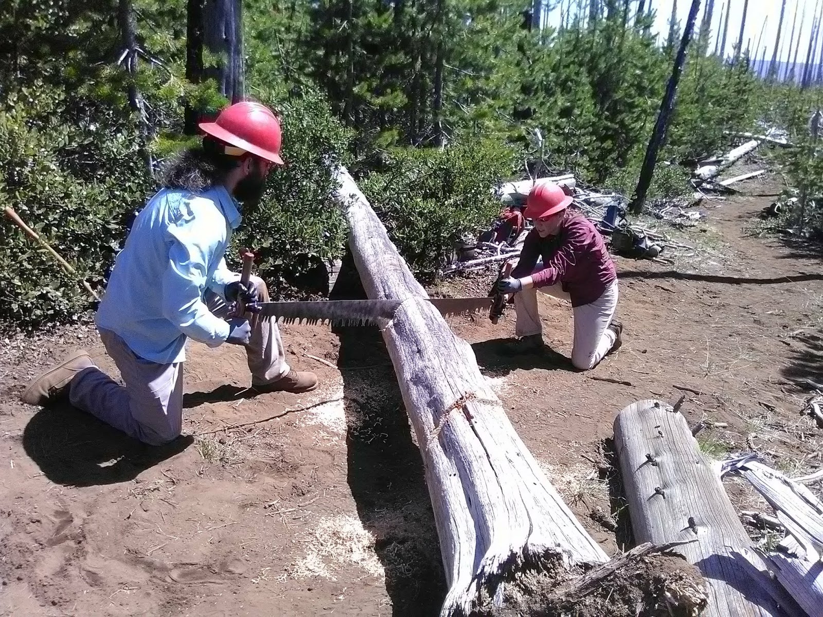 |
| Zach and I tackle a downed log |
After the harrowing first day of classes, Zach and I were both ready to tackle the much-tamer Trail Maintenance 101, which would focus on "brushing"— clearing the trail for both hiker and equestrian use. The day began with an elaborate breakfast, prepared by an equestrian group who had set up a huge pavilion and served eggs, sausage, hash, fruit salad, and oatmeal. A delicious start to the day! We wolfed down the food, then met at a gravel parking lot to see who would be in our class with us.
The entire trail class was close to 30 people, but we split into three groups, and we'd divide further to hop into Forest Service trucks to head out to a trail for some hands-on experience.
Our group leaders were Dave, a Forest Service Ranger about our age who had backpacked more miles than I can dream, and Jim and Ginny, an older couple who had spent their lives in service of the wilderness. Our class also included search-and-rescue expert Sue, former Bureau of Land Management worker Bob, a sweet guy named Mark that I never got to talk to, and a young woman named Natalie who had thru-hiked the PCT last year. Dave, Bob, Natalie, and we crammed into a truck together, comparing notes on our hikes while Bob peppered us with questions and Dave fishtailed up some ridiculously bumpy dirt roads.
 |
| Zach, Natalie, Dave, Sue, Ginny, Jim, Bob, and Mark at Square Lake |
We ended up near the creatively-named Round Lake, which settled into the folds of hills that had been burned down to the mineral soil 16 years earlier. The hills were blanketed with manzanita, beargrass, and brush, along with lodgepole pines racing to reclaim the canopy. Blackened spears of trees stuck up everywhere, reminding me that forests take a very long time to regrow.
 |
| Jim helping Zach cut out a lodgepole pine |
Although the night had been chilly, it was searingly hot as we regrouped at the sunny trailhead to discuss safety and the function of the various tools: hazel hoe, Pulaski, McCloud, hand saw, loppers, shovel. I had used most of the tools before, and had a bit of experience with brushing from our last volunteer trip, but it was good to review.
Decked out in hard hats, long sleeves, sunglasses, and work gloves, we each grabbed a couple tools and began slowly walking up the trail, stopping almost immediately to discuss the brush situation and clip back some manzanita. We inched up the trail, brushing and discussing as we went, pausing to cut out some young lodgepoles growing too close to the trail, then moving on.
A family riding horses passed us, then after a little while returned, saying that fallen logs were blocking the trail up ahead. Dave asked how big the logs were, and after the riders had left, he and Jim and Ginny discussed it while we worked. Since we were in a designated wilderness area, motors— and therefore chainsaws— were not allowed. Someone would have to crosscut-saw the logs.
We spent a solid couple hours sweating through the brush clearing, at last stopping for lunch on a pile of dead logs. I was dearly wishing for some live trees to offer shade, and chugged my water.
Our crew leaders said that we seemed pretty competent on brushing, so they went ahead and dived into part two of the trail maintenance class: drainage and grading. A properly-formed trail needs little maintenance, won't turn into ruts, and won't wear out, and good drainage areas are essential for this. We started walking back down the way we'd come, this time imagining ourselves as drops of water eager to erode the trail. Where could we be diverted to avoid damaging and wearing out the trail?
Again, Zach and I had worked on this concept before, and soon everyone in the group had picked it up fairly well, scraping and forming the ground, widening existing drains, reshaping others. Once you start getting "trail eyes," it's hard to go back— now I feel like a drop of water every time I set foot on a trail.
 |
| Me with my favorite tool, the McCloud |
Due to the heat, class ended early that day, but not before they promised us that we would introduce a new element tomorrow, one that wasn't supposed to be included in this class: crosscut sawing! Zach and I had both been very interested in learning more about crosscut, so we were excited. Plus, the thought that we'd be doing something tangible to make this trail more accessible was cool.
We had plenty of time to relax and hike along the river that afternoon, and then after a delicious dinner that night, we sat through a ceremony in which the organizers thanked the volunteers who made the college happen, the various trail organizations in attendance talked about their work, and they called out trivia questions so people could earn prizes. (I correctly remembered one of the acronyms from First Aid and won a PCTA tote bag.)
We were up and at 'em early the next day, treated to another hearty breakfast. We piled into the same truck with the same group of people and wound up the mountainside, chatting about trail experiences and asking stories.
Once at the trail, we reviewed some of the previous day's work (they had brought a tennis ball, which they'd drop on the trail— it demonstrated how water would flow on the trail and whether the drainage slots we'd widened were sufficient), then tromped onward to find the fallen logs that the riders had noted.
The trail was wide open and green, with wonderful views of snowy mountains in all directions— Three-Fingered Jack, Washington, and the Three Sisters. Today was less hot, even though I was still sweating from wearing long sleeves. As we hiked, we chatted with Dave about his backpacking trips— the Pacific Crest, the Continental Divide, and a long-distance trail in Patagonia— and compared notes with him and Natalie about the PCT.
At last we came to the first of what turned out to be 11 downed logs over the trail— the burned trees, standing placidly for 16 years, had finally given up the ghost. Jim and Ginny unpacked the crosscut blades and screwed on the handles, and we discussed all the factors to consider before starting to cut (which were tucked into yet another acronym, and a convoluted one at that). Working with big logs can be dangerous in many different ways!
 |
| Zach and Mark on crosscut |
Finally it was time to cut, and we took turns, subbing in and out. At worst it felt like a really bad game of tug-o-war, but when the other sawyer and I were in sync, it took hardly any effort and the tension of the saw felt just right, like it was moving back and forth on its own and I was just guiding it. Dave pointed out the "noodles" of cut wood falling out under the blade, indicating that we were cutting smoothly.
After several minutes of working our way through the 14-inch log, the first cut was made, which I finished with a handsaw. Dave said that experienced sawyers could cut a log this size in less than a minute!
We worked our way through 11 logs that day, completely clearing the trail all the way up to the nearest junction. We paused late in the afternoon for lunch by the glittering shore of Square Lake, where— hallelujah!— some mature trees had survived to give us shade. Then we hiked out, reviewing our work, loudly congratulating each other on each cut log that we passed, and feeling like we had gained some valuable field experience.
We did a quick debriefing, and then dispersed, graduates of the college that had given us some valuable new skills. Zach and I met up with Gary at the campsite, where we'd stay one more night before heading to Bend in the morning. As we toasted marshmallows that night, I felt satisfied— the weekend had been a success!
~~~
Subscribe to:
Posts (Atom)