Showing posts with label oregon. Show all posts

Saturday, July 3, 2021

Flying


Last Sunday, Zach and I were up in the air again. Masked and loaded up with backpacks, we shuffled onto the plane and settled into our seats for our flight from St. Louis to Portland, Oregon. After so many years of piecing together shorter flights and long layovers, I always feel like I'm teleporting when, a mere four hours after takeoff, we land in the alternate reality that is the Pacific Northwest. (This reality was obviously from a different timeline than usual, though: how else could you explain the 111ºF temperatures?)

Saturday, August 15, 2020

Scenes from the Northwest


We booked our flight to Portland a few eons ago, hoping that the pandemic would be well contained by then and that we'd feel confident about flying. Eons passed(I don't remember much of it, just lots of hiking to the music of cicadas, and teaching people about sourdough bread, and hours spent staring into the void [aka the internet]), and we made the decision to go anyway. We wanted to visit family. We wanted to hike beside the waterfalls and breathe the smell of pine needles warmed by the alpine sun.

Friday, October 4, 2019

Portland 2019: Cottonwood Canyon State Park, Oregon

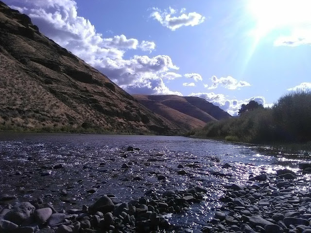
The John Day River


Before we hopped a plane to Missouri, we had time (and good weather) for one final mini-trip: a two-night camping trip with Gary to Cottonwood Canyon State Park in the desert of central Oregon.

Cottonwood Canyon was once a ranch, but was recently acquired by the state and transformed into a brand-new park full of amazing facilities— lush campsites along the willow-clad John Day River, camper cabins, bike amenities, free bikes to use while you're there, board games to borrow, a solar charging station, showers, and more! The arid hills rise up on all sides, but are widely-spaced to keep you from getting claustrophobic. 

Our first day, we set up camp and hiked the Pinnacles Trail, which took us 4.3 miles (and possibly further, when we consulted the map) down Cottonwood Canyon and sideways into Esau Canyon, all the while paralleling the river. Ravens wheeled far overhead, sparrows chirped from the underbrush, and we saw many deer hoof prints in the sand. The river reflected the yellowish hills and the blue sky, creating an intense melting palette of blue and orange. 


That night, some clouds rolled in, but we were still able to see some stars, including the thick band of the Milky Way. 

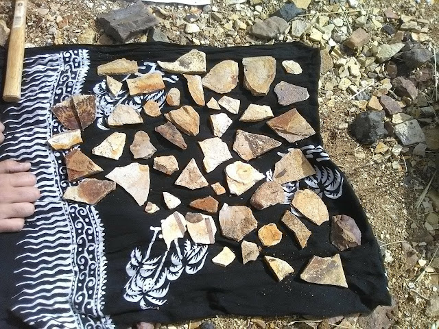
The next day, we did an hour-long road trip over the plateau and amongst huge lines of windmills to the town of Fossil. A chatty and helpful woman at the Oregon Paleo Lands Institute Center gave us directions to a field where we could dig fossils in exchange for a small donation to the local high school. We walked through the sleepy town, climbed a hill, ducked behind the high school, paid a fee, grabbed some of the tools in a crate, and began shoveling through the dirt on a hillside in search of fossils of 40-million-year-old pines, alders, and maples.

It took us a while to get our "fossil eyes" on, but once we did, we found a lot! We took pictures of many, but only kept a few. I searched through shards, while Zach chiseled apart layered rocks to find the fossils sandwiched in between.


That night, back at Cottonwood Canyon, we walked a three-mile trail up the canyon, then started a charcoal briquet fire (regular campfires were forbidden due to sparks) and roasted marshmallows. Some rain spat on us, but it never got too bad.

Zach said that the rocks around here look like low-resolution computer graphics because they're just shards.

The next day we drove home, and Zach and I quickly shifted gears into finishing up our final packing. But I was very glad we got the chance to visit this slice of Oregon's beautiful desert.


~~~

Saturday, August 24, 2019

A Jaunt on the PCT II, Day Three

A mountain with grayish splotches of burnt trees


August 20th, 2019:

I awoke in the earliest watch of the morning, when the sky was gray with a few stars still lingering, to the sound of a barred owl hooting in a tree nearby. I took out my earplugs to hear him better, listening to the rhythmic Who-cooks-for-you, who-cooks-for-you-all echoing across the lake in the morning stillness. Then I immediately fell back asleep.


I woke up a little while later, when the sky was still gray but a flaxen light was starting to paint the rim of the eastern mountain ridge that rose up as part of the bowl that encased Wahtum Lake. Zach and I packed up quickly and were on the trail by 7:15, just as golden light was pouring onto the uppermost trees on the far ridge.

My shins and calves were super sore, and we both knew that the hike today would entail a lot of downhill, as we were heading into the Columbia Gorge to meet Gary at Cascade Locks. The hikes of the past two days had been difficult, and I'd never felt like I'd gotten enough sleep, and that, combined with my muscle aches and the weather growing sticky and warm, made me feel leaden with exhaustion. We walked slowly and took lots of breaks, but I could not push myself harder.

Checking out this huge mushroom!

Although the forests were similar to the ones of the past two days, we wound in and out of distinct ecosystems, such as fir forests where the ground was carpeted almost entirely with waxy, bluish clumps of beargrass. 

Soon we began ducking in and out of burned areas that stretched from the gorge up onto the hills like fingers. I grimaced at the rows of scorched trunks, but Zach reminded me that the forest is supposed to reset every couple decades— and if a single spark from a firecracker was enough to set the entire gorge ablaze, it meant that the forest was past its due. Wanting the gorge to be only lush and green on our terms was pure nostalgia, not actually what's best for the woods.

"Still," I said, "it's sad that there are people around who will never live to see the forest in full glory again."

"But that's just a human perspective," Zach said. "An old forest that hasn't been burned in too long isn't a fire ecosystem in its full glory. Every stage is important. Humans just like certain stages less than others."


I looked around at the blackened trees, which had a handsome ombré effect due to the scorched bark giving way to sun-bleached wood above. Clumps of beargrass and whips of huckleberries were slowly retaking the ashy ground, and among the shards of burnt bark on the ground you could see fir trees half an inch tall, bristling like green stars. Black-and-white hairy woodpeckers flitted between the dead trees, rattling the silence with their pecking. The forest was still very much alive, just not in the way we're used to. The glory of a fire ecosystem is to be what it is, no matter what stage.

Still, I was glad we had hiked the Eagle Creek Trail when we'd had the chance.

The day grew hotter as we hiked back into live trees and started a never-ending downhill that hurt my tense muscles so badly that I groaned with every step (Zach was faring no better, with his knee hurting). Popping some Ibuprofen helped, but it was just a matter of getting through it, switchback by switchback. We got some last beautiful views of Mount Hood and Mount Adams before we disappeared behind the ridge of the mountains that stand right at the banks of the Columbia River: the blue water called to us from a thousand feet below, and we limped toward it.


After a couple hours of tedious and painful downhill, we paused by a spring to gather water and rest our sore legs. Unlike the still warmth of the forest, this cleft in the rock was a channel for cool air, which tumbled down from the mountain heights along with the water. Here we revived a bit, and felt better as we headed toward the last several miles of the hike.

The trail more or less leveled out now, winding us alongside the mountain shoulders, past twenty-foot-tall triangles of volcanic rock, and through woods that became full of familiar plants: cat-ears, Oregon grapes, big leaf maples, licorice ferns. 

We popped out into a gravel parking lot, followed PCT blazes on telephone poles down the road, ducked under a bridge, and came out at a little park right next to Bridge of the Gods, where Gary was waiting to pick us up.

We collapsed in the car, aching, sweaty, and stinky— and satisfied that we had completed this breathtaking section of the PCT. That night, I slept twelve hours straight.

 ~~~

Friday, August 23, 2019

A Jaunt on the PCT II, Day Two


August 19th, 2019:

I woke up the next morning feeling completely better, although quite sleepy from lying awake so long. I didn't have much time to snuggle into the sleeping bag, though; we were hoping to cover 20 miles today, and our aching legs reminded us that this terrain was more difficult than the section of trail we'd hiked in central Oregon.

Last time we'd crossed the Muddy River, Zach had done gymnastics to clamber across a log, and I had just waded straight through and been grumpy the rest of the day. Five years later, the log's huge root ball had been eroded, making it easier to manage even with a backpack. We inched across one log that was almost entirely overlapped by a bigger log, and although the footing was slippery, we made it in one piece, and started up a steep climb through a fir forest limned with golden morning light. 

Also I got Zach to punch this tree like he's in Minecraft, in order to imitate a picture we took on our thru-hike (see below). He insisted it was far too early in the morning for such theatrics, but accommodated me anyway.

The original Minecraft-punching photo, 2014. Wow, Zach was starved back then. 

The forest today continued to be thoroughly Northwestern: water seeping through the volcanic rock, never-ending stretches of Douglas fir, mushrooms of all shapes and sizes pushing up through the pine-needle duff, scraggly lichen and shag-carpet-like moss coating the trees. We crossed a campground and walked under some power lines, then toiled up a hill to follow a windy ridge carpeted in berry bushes. We snacked on the refreshingly tart huckleberries, the fuzzy-skinned but deliciously jammy thimbleberries, and even the occasional salmonberry even though they're bland. We pressed on for a while, then took a stop at a campsite for a little nap. Although I didn't sleep, it felt good to lie down.


Note the beautiful red elderberry


After a while, though, we were feeling the time crunch, so we hiked onward, following the line of mountains on a fairly level path. We began crossing moraines— fields of rock carried there by glaciers— walking slowly to listen for the telltale dog-squeaky-toy sound of pikas, an alpine relative of rabbits. To our joy, we did hear them, and later that day, we saw movement among the rocks, and a furball the size of a guinea pig hopped up onto one of the stones, its round ears and whiskers twitching. It had been five years since we'd seen these adorable creatures, so we were pretty excited!

Toward the end of the day, we emerged from the trees to an open ridge and a spectacular vista: Mount St. Helens off to our left, Mount Adams looming to our right, and the distant peak of Mount Rainier in between the two. We walked slowly across the open trail, flanked by carpets of heather and clumps of a trumpet-shaped blue flower called gentian. Overhead, huge ravens wheeled, and a pair of some sort of stout falcon took flight from the few remaining trees.

Zach and I walked along the ridge in open-mouthed wonder. "Why on earth don't I remember this?" I asked, and Zach reminded me that last time we'd been here, it was morning and a fog had settled over the nearest ridge of mountains. I was glad we got a second chance to see it in the golden evening light!

If you look closely you can see St. Helens to the left, Rainier in the middle, and Adams right by Zach's head.
Gentian


From there we dropped down into the woods again, and paused at the junction of the PCT and Eagle Creek. On our thru-hike, we'd taken the Eagle Creek alternate because of its legendary beauty and notable features, including a waterfall with a tunnel underneath that you could walk through. Now, that's not an option: Eagle Creek was closed a few years ago after a raging human-caused wildfire. The forest, which is a fire ecosystem, will bounce back, but everyone who loved hiking there was devastated.

So Zach and I hiked on, following the official route of the PCT to see what the twenty-mile section would bring us. Darkness was gathering, so we stopped at a campsite on the shore of the shimmering slate-gray Wahtum Lake. Zach set up the tent while I filtered water and watched an osprey wheel far overhead, crying plaintively. 

That night, I laid back, smiled at the firs silhouetted above us, and plunged into exhausted sleep.

 ~~~

Thursday, August 22, 2019

A Jaunt on the PCT II, Day One


Earlier this week, Zach and I were able to do a three-day hike from Timberline Lodge to Cascade Locks! Here's my journal from the trip…

Day One, August 18th, 2019

We woke up late and ate a leisurely breakfast, getting on the road with Gary by about 10:00. It was cloudy in Portland, but once we started climbing toward the peak of Mount Hood, we left the clouds behind and sailed through the winding roads under clear skies. Around noon we pulled up to Timberline Lodge, ready to continue where we'd ended before.

Gary, Zach and I hiked up past the lodge and turned left on the trail emblazoned with a huge PCT emblem, and joined a scurrying line of people heading alongside the mountain. To our left, Timberline Lodge was framed by the undulating blue mountains and the distant peak of Jefferson. Pale lavender Cascade asters grew in evenly-spaced clumps across the sandy ground, forming meadows between the firs.


We paused at the edge of the Mount Hood Wilderness to fill out a permit, then joined the long line of people hiking into the wilderness. Although we've certainly hiked in more crowded places, it felt anything but wild out here, and we had to constantly stop and step off-trail to let people by, or say "excuse me" and power past slower walkers.

After a couple miles, the crowds began to thin, and as we delved down into a valley and crossed a little stream, only a few hikers remained. 

Gary had previously suggested that we take a little detour onto the Paradise Park loop, a trail that hooked up with the PCT in this section, and we agreed. So instead of continuing on a flat trail among the trees, we turned to the right and hiked between thickets of huckleberries and red elders toward the timberline. 

Before long the trees began to clear, and soon we were in a landscape dominated by meadows— and such meadows! I gawked, unable to believe the sheer beauty and diversity I was looking at. 

Thickets of purple lupine, spikes of bright red Indian paintbrush, clumps of Cascade aster, little sunbursts of arrowleaf groundsel, spikes of Cascade Canada goldenrod, white flower-clusters of American bistort, shapely leaves of green false hellebore sticking out like florists' decorations, and a bunch of other flowers I couldn't identify: all forming the most gorgeous gardens I could imagine. None of the meadows were uniform; each one was shaped by the slope it was on, and lines of color marked where streams flowed down and encouraged new flowers. On the dry meadows the lupine and asters reigned; along the trickling streams, pink clumps of purple monkeyflower and scattered subalpine mariposa lilies became dominant. I floated through the flowers in a dream.


See how the drift of yellow flowers indicates a stream?


After a few hours of hiking, the trail rejoined the PCT, so we said goodbye to Gary and parted ways: him back along the loop, and us forward into drier and more forested terrain.

We hiked down the mountain, ate peanut-butter-chocolate wraps at a campsite near a creek, then set out onto a boulder field to cross the Sandy River.

Even here so near its glacial source, the Sandy River is a raging torrent of opaque water. Zach and I approached, looked at some thin logs laid across the river— right at the water level, slick and shiny— then tried to find another way. There wasn't one, so we took deep breaths and approached the makeshift ford. It was less than ten feet to cross, but the water looked deep and dangerous. A wrong step could get you soaking wet at best and a broken bone at worst. 

Zach went first, inching across, and then I followed, my legs trembling the whole way. Then we laughed in relief on the opposite bank, tried to find the trail through the unmarked boulder field, and ducked back into the forest.

It doesn't look like much, but it's a torrent!

Hooray, we made it!
We ended up taking a short detour that we'd taken before, to see Ramona Falls. I'd remembered the falls as being pretty, but when we approached, I was shocked to find yet another feature that I'd remembered smaller than it was. The 120-foot face of black volcanic rock rose up through the trees, laced with an incredible embroidery of falling water. Zach and I gaped.

We traced our path through the woods, which were flooded with stripes of golden evening light. We stopped to talk to an Australian woman who was visiting the Northwest for the first time— beautifully dark-skinned and full of friendly joy, she was soaking it all in and happy to share the wonder.

This part of the trail was particularly scenic: a carpet of moss rolled over everything, trees grew out of boulders and rotting logs, mushrooms pushed up silently, slugs made a slow-motion slither across the trail, and the sunlight filtered through the fir trees.

The bridge and person are considerably closer than the falls, making it look smaller than it is. 120 feet tall!

Unfortunately, around this time I began to have stomach trouble— not enough nausea to keep me from hiking, but enough to be unpleasant. By the time we stopped at a nice campsite along Muddy Fork River, I was more than ready for rest.


Because of my roiling stomach, I wasn't able to go to sleep, but I tried anyway, putting in earplugs and closing my eyes. I drifted in and out for a while, and as the woods grew dark I noticed that the trees around us were faintly illuminated. My half-asleep brain couldn't figure out why, until I craned my head back and saw a bright white light shining through the woods far away. I thought it was a headlight at first, until I realized that it was actually the moon. So I laid awake in the moonlight and marked time by watching it rise, slowly, slowly, through the trees.

~~~

Monday, August 5, 2019

A Jaunt on the PCT, Day Four

Us on Mount Hood with Mount Jefferson in the background


We woke up late on our final day, sleepy and sore— the high mileage combined with us being out of shape was catching up to us! We walked less than a mile to the campground, drew water from the creaky pump, and sat at a picnic table to eat oatmeal and watch the chipmunks and golden-mantled ground squirrels scurry around.

Although we only had ten miles to hike today, the elevation gain was more than the entire rest of our trip combined. Still, we weren't in a huge hurry, having promised to meet Gary at Timberline Lodge around four or five o'clock. 

We hiked a slightly steeper trail through the woods, pausing at a trailhead that had a picnic table and… some chin-up bars, maybe? We weren't sure what they were there for, but Zach did some chin-ups, anyway. We chatted with a guy from upper Wisconsin, ate some peanut-butter chocolate wraps, and hiked on.

Zach likes to climb stuff...

From here the trail started winding its way up the flanks of the mountains, and although we were still in the forest, we began crossing more meadows, and the whole feel of the area grew more alpine. 

As we started the steepest part of the climb, my lungs began burning and I felt like I couldn't get enough oxygen— the sensation felt like the beginning of a panic attack. We had to stop several times, and eventually Zach took some of the weight from my pack, and I walked with my chest strap and hip belt un-clipped to give my body more room to expand when I drew deep breaths.

Because of my breathing trouble, we walked very, very slowly. Soon this was inevitable anyway: we cleared the timberline and found ourselves walking across fine sand that swallowed every step. We had nothing to complain about, though: we were in a wonderland of wildflowers and dramatic views. Hood's peak loomed ahead, gray slopes of bare rock dropped off into dramatic cliffs, a few tough pines offered intermittent shade, and the trail cut a line through a meadow of tough grasses, mountain ash bushes, and thickets of purple lupine that gave the cold breeze a strong fragrance like lilac.


We paused to catch our breath and looked behind us to see a watercolor-blue collage of mountains undulating into the distance, with Mount Jefferson's peak standing above the rest, and Mount Washington barely visible behind its left shoulder. Far to the left, the blue gave way to tan, showing us the deserts of Eastern Oregon.


After a break, we huffed and puffed on, most exhausted than we felt was reasonable, but still enjoying the views. We reached the right elevation and the trail leveled out, leading us alongside the mountain peak. Now that we weren't climbing, we walked faster, and I was even able to rebuckle my straps. We heard live music drifting over an arm of the mountain, cleared the slope, and saw the spire of Timberline Lodge below us.


We ate vending-machine Fritos with the last of our hummus for a pre-dinner snack, and soon Gary came to pick us up. I melted into the car seat, aching from every muscle, but smiling.

The shower that night felt amazing, but the bed was too soft.

~~~

Sunday, August 4, 2019

A Jaunt on the PCT, Day Three


I woke early to see mist floating over Timothy Lake, and promptly fell back asleep, waking for real only when the sun cleared the hill behind us and poured golden light onto the trees. A raven croaked from a treetop across the water, and ospreys dove for breakfast.

Since we were going to hike around the lake today, we stashed my pack and most of our gear in the woods near some trail crossroads, then took turns carrying a day-pack for the 13-mile loop.

The weather continued to be warm and unbrokenly sunny with a cool breeze. The trail was flat and soft underfoot, meandering around the lake over a dam, through natural areas, alongside day use areas packed with people and inflatable swim rafts, in between campgrounds, and into the forest. We paused on one of the beaches to soak our sore, blistered, dusty feet in the cool lake. With our toes in the water and a great view of Mount Hood ahead, we were content to sit around for quite a while.


At last we finished the loop, recovered our gear, and headed a few minutes down the trail to Little Crater Lake, a perfectly clear spring 45 feet deep. The cerulean water is stunning! 


As we sat in the grass rehydrating refried beans for dinner, a thru-hiker with a canvas tarp rolled onto his pack walked up, and we invited him to sit with us. We learned that he, like many people this year, had planned to hike northbound, but had hit a hard stop with the insanely high snow in the Sierra this year, forcing him to travel to Canada and hike south the rest of the way.

He was serious and sincere, opening up about how emotional it was for him to lose his "trail family" when the Sierra split everyone up. Originally from Hong Kong, but spending most of his life in San Francisco, he had grown up hearing stories of the PCT and had always wanted to hike it. With turning 30 this year, he realized that life was slipping away and that he should chase his dreams now.

We talked with him for a long time, chatting about everything from hiking philosophy to how culture influences our ideas about family and community. We shared some of our dehydrated hot sauce with him. A cyclist walked over and asked if we were thru-hikers ("Yes, but not this year," we replied), and we chatted with him for a while about his adventures cycling across the US and hiking sections of the PCT, Appalachian Trail, and Continental Divide Trail.

By this point an hour or so had passed, so Zach and I packed up, wished the thru-hiker good luck and safe travels, and hiked back down the trail. We walked a few miles, gathered water from a spring while dodging mosquitoes, then hiked on to find a place to camp.

Although the gently-sloping woodlands probably had some good campsites, we weren't tired yet, so we kept walking until the trail cut along the side of a very steep, several-hundred foot slope of trees, with a bank of rhododendron on our right and a sweeping view of the fir-blanketed mountains, and, looming large, Mount Hood's peak, to our left. It was the "golden hour" of the day, the view both sharpened and softened with the evening glow. 

We watched Mount Hood's peak slowly march by, flanked by deep woodlands and an occasional stretch of meadow. Behind us, the sun dipped toward the mountains, casting stripes of dappled light over the trail. I felt hushed by the magic.


At last we plunged back into the woodlands, and realized that we had almost made it to the next water source, at a designated campground. Since we didn't want to pay to camp, we ended up pitching our tent a hundred yards from the highway that weaves its way up to Mount Hood. The sound of trucks passing by all night wasn't exactly a wilderness experience, but the stars were beautiful.

~~~